PhotoMapper v0.7 GPS Import Help
Warning: Undefined variable $lang_hst_hdr in /home/copikss/public_html/software/photomapper/help/v07/gpsimport.php on line 80
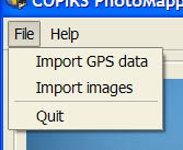
Select Import GPS Data in the File menu.
Find and select a tcx, hst, gpx, nmea or log file in the file dialog that appears.
When GPS data has been imported the table in the GPS data tab will be filled with data from the individual GPS-logs found in the file. By clicking the plus sign before each item more details can be found. Large GPS-data files might take some time load.

The imported tracks are shown in green on the the Google Maps-view if they are selected in the tracks list.

|

